Kerch Sea Port
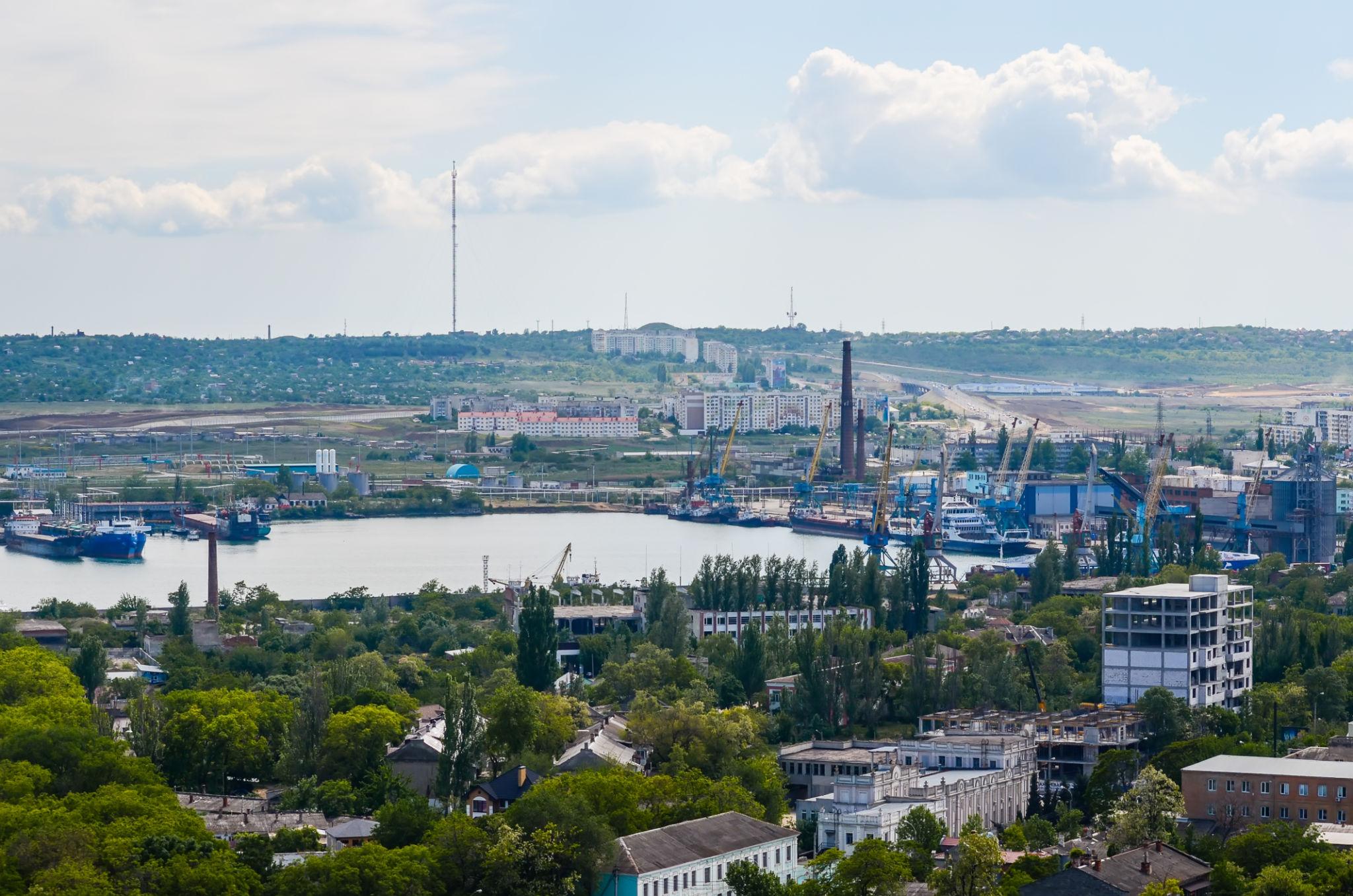
Kerch Sea Port (Керченський морський порт) is a Ukrainian seaport on the eastern coast of the Crimean Peninsula, situated on the strait linking the Black Sea and the Sea of Azov. Its commercial history developed around the redistribution of cargo between these two seas, with important fishing, industrial and ferry operations in the wider port area. Russia has occupied Kerch since 2014. Ukraine closed the port to shipping on 15 July 2014; activities conducted under Russian control do not constitute a lawful reopening.
Reference profile updated 20 November 2026. Technical figures describe historical infrastructure or explicitly dated inventories, not present vessel acceptance, operational readiness or navigational safety. The commercial port, fishing port, industrial facilities and ferry crossing are distinguished throughout.
At a glance
| Parameter | Details |
|---|---|
| Country | Ukraine |
| Location | Kerch, Autonomous Republic of Crimea; Kerch Strait |
| UN/LOCODE | UA KEH (OFAC reference record) |
| Commercial port established | 1821; opened for trade in 1822 |
| Port type | Multipurpose commercial port, with separate fishing, industrial and ferry facilities in the wider maritime area |
| Historical commercial port enterprise | State Enterprise Kerch Commercial Sea Port; Ukrainian registration code 01125554 |
| Historical address | 28 Kirova Street, Kerch, Crimea, 98312, Ukraine |
| Commercial port berths (2012) | 10, including seven multipurpose berths; combined length 2,008 m |
| Historical maximum vessel draft at commercial port | 8.1 m (2012 reference) |
| Cargo throughput (2013) | 2.791 million tonnes, USPA statistical series |
| Historical cargoes | Oil products, coal, coke, ore, grain, metals and general cargo |
| Status | Temporarily occupied by the Russian Federation; closed by Ukraine since 15 July 2014 |
Sources: Encyclopedia of Modern Ukraine, 2012; USPA figures reported in January 2014; OFAC; official Ukrainian statement, 2017.
Geography and transport connections
Kerch lies on a sheltered bay on the western side of the Kerch Strait, the natural maritime connection between the Black Sea and the Sea of Azov. The shallow Azov basin historically encouraged transshipment between vessels of different sizes. The commercial harbour is only one part of the maritime economy of the strait: navigation services, offshore cargo handling, fisheries, ship repair and the separate ferry crossing have all contributed to its economic role.
Road and railway links historically connected the city to the Crimean network and, through the peninsula, to mainland Ukraine. The railway ferry established a separate connection with the Caucasus. The Kerch–Yenikale Canal historically supported navigation between the two seas; revenue and traffic associated with passage through the strait should not be confused with cargo loaded or discharged at the commercial quays. Port statistics may also include offshore transshipment rather than exclusively alongside operations.
History
Kerch developed on the site of ancient Panticapaeum, a major centre of the Bosporan Kingdom. Its location made maritime exchange a durable feature of the local economy long before the establishment of a modern port administration. After the period of the Crimean Khanate and Ottoman influence, Kerch came under the Russian Empire in the eighteenth century.
The modern commercial port dates from 1821. Its initial function was to facilitate trade with the ports of the Sea of Azov, whose shallow waters made the movement of cargo between inland and seagoing vessels economically important. Trade began in 1822. Customs and quarantine arrangements developed alongside the port. The nineteenth century also saw development of local iron ore extraction and metallurgy. See the Internet Encyclopedia of Ukraine and the historical study Controlling the Straits: The Development of the Port of Kerch.
The city's industrial and maritime facilities were severely affected by the Second World War. Reconstruction in the Soviet period created a diversified maritime centre, with the commercial port, fishing infrastructure, shipbuilding and ship repair. A separate fishing port was founded in 1949. The rail ferry across the strait supported interregional transport in the Soviet economy.
After Ukraine regained independence in 1991, Kerch developed as part of the Ukrainian maritime transport system. The disruption of former Soviet supply chains and the decline of regular railway ferry traffic affected its business. Cargo transshipment and transit subsequently became important sources of activity. The 2013 port reform separated public port administration from commercial operations through the creation of the Ukrainian Sea Ports Authority. Russia's occupation in 2014 interrupted this institutional development.
Commercial terminals and infrastructure
Kerch Commercial Sea Port
The Ukrainian technical reference published in 2012 describes two cargo-handling complexes. The following figures belong to that historical enterprise and must not be added to post-occupation inventories without reconciling their boundaries.
| Indicator | Historical figure |
|---|---|
| Multipurpose berths | 7 |
| Additional cargo berths | 3 |
| Total berth length | 2,008 m |
| Open storage | 104,000 m² |
| Covered storage | 18,400 m² |
| Maximum ship length | 220 m |
| Maximum ship draft | 8.1 m |
| Alongside vessel cargo capacity | Up to 20,000 tonnes, as reported |
| Employment | Approximately 1,800 (2012) |
Source: Encyclopedia of Modern Ukraine, 2012. These are historical reference values, not a current port specification.
Published design inventories provide further detail on the seven numbered commercial berths. The following figures are from the Russian administrative document first issued in 2015, in its January 2024 revision. They are reproduced only as an infrastructure record from the period of occupation, without recognising Russian jurisdiction. Design depth means the intended engineering depth of the structure, not a measured depth or permissible vessel draft.
| Berth | Length, m | Design depth, m |
|---|---|---|
| 1 | 231.74 | 6.7 |
| 2 | 130.10 | 3.2–6.7 |
| 3 | 258.05 | 6.7 |
| 4 | 185.70 | 8.5 |
| 5 | 198.80 | 8.5 |
| 6 | 197.60 | 9.75 |
| 7 | 214.90 | 9.75 |
| Port fleet berth (separate) | 231.00 | 3.8 |
Source: Russian Ministry of Transport Order No. 313, Appendix 8, 2015, revised 10 January 2024. The listed subset does not cover every facility in the 2012 inventory. It is not a statement of safe access.
A contemporaneous report published in January 2014 put the nominal annual capacity of the seven-berth commercial port at 2.5 million tonnes. The substantially larger 2012 reported throughput of the port area demonstrates the importance of distinguishing shore-based capacity from wider cargo operations. The 2012 Ukrainian reference also records offshore transfer using specialised craft for ships exceeding the dimensions normally handled at the quay.
Kerch Fishing Port
The fishing port developed as a separate state enterprise, initially serving fisheries and later handling diversified cargo. Construction during the 1950s added a sheltered artificial basin with a reported area of 25 hectares. In subsequent decades its refrigeration facilities and oil-handling infrastructure expanded. The shift towards general commercial cargo following the Soviet period reduced its dependence on fish products.
| Facility | 2011–2012 reference |
|---|---|
| Berths and rail | 7 berths; approximately 5.3 km of access railway tracks |
| Vessel dimensions | Length up to 200 m; draft up to 6.9 m |
| Cargo yards / covered warehouses | 10,100 m² / 1,500 m² |
| Grain elevator | 30,000 m³ |
| Cold storage | Up to 7,000 tonnes, at temperatures as low as −20°C |
| Petroleum product storage | Seven tanks of 5,000 m³ each |
| Lubricants storage | 3,200 tonnes |
| Crude oil handling | Historical rated unloading capacity of 480 t/h |
| LPG handling | Historical rated capacity of 1,000 t/day |
| Cranes | Portal cranes rated 3–20 t; gantry cranes rated 25 t |
| Employment | Approximately 450 (2011) |
Source: Encyclopedia of Modern Ukraine: Kerch Fishing Port, 2012. Rated handling capacities are not demonstrated annual throughput. Current asset availability is unverified.
Kamysh-Burun and other maritime facilities
Kamysh-Burun (Kamysh-Burunskyi port) is a distinct industrial harbour associated historically with local iron ore and metallurgical activity in the southern part of the Kerch maritime area. The city also has shipbuilding and ship repair enterprises. These assets are not included in the commercial port's ten-berth inventory. A reliable consolidated pre-occupation asset inventory and verified recent civilian throughput series for Kamysh-Burun were not established for this profile.
Kerch ferry crossing
The ferry crossing, based in the separate Port Krym area, historically connected the peninsula to the Russian shore of the strait and served passengers, vehicles and rail wagons. It was distinct from the numbered commercial cargo berths in central Kerch. The crossing became much more important after the occupation, then lost traffic after the opening of the bridge. Ferry volumes and tonnage handled by the commercial harbour are therefore different measures.
Cargo-handling equipment and port fleet
Kerch's multipurpose equipment supported handling of mineral bulk, metals and other conventional cargoes. A World Bank transport-sector assessment based on late-1990s conditions (Annex 9.1, paragraphs 25–26) recorded 35 quay cranes across the seven principal berths, including units of up to 40 tonnes. That historical equipment count is not a 2013 or current inventory. The Ukrainian 2012 encyclopedia describes floating cranes rated at 16, 25 and 100 tonnes and specialised cargo barges, indicating that marine transfer equipment was an important component of the port's business.
The harbour service system historically included towage, mooring support, pilotage, cargo barges, floating lifting equipment and ship repair services. The fishing port also operated its own marine transport assets in the Soviet era, including refrigerated ships and tankers. The 2012 account is not a complete vessel registry. No reliable contemporary count of operational tugs, pilot launches, waste-reception craft or floating cranes is available in the reviewed sources; the status of individual vessels after confiscation cannot be inferred from historical lists.
At the time of the occupation the separate ferry service included railway ferries Annenkov and Petrovsk, and vehicle ferries Kerchensky-2, Yeysk and Nikolai Aksenenko, according to the Centre for Investigative Journalism. They should not be counted as commercial port tugs or cargo-handling vessels.
Cargo and passenger traffic
The last complete pre-occupation year was already difficult. USPA data published by the industry in January 2014 show a 58.4% fall in total cargo turnover compared with 2012. Oil products proved more resilient than dry bulk, while the loss of grain traffic was particularly severe.
| Cargo | 2012 | 2013 |
|---|---|---|
| Total | 6,707 | 2,791 |
| Liquid bulk | 2,362 | 1,947 |
| Dry bulk and other dry cargo | 4,196 | 825 |
| Of which coal | 1,718 | 538 |
| Of which coke | 151 | 60 |
| Of which ore | 304 | 151 |
| Of which grain | 1,932 | 20 |
| General cargo | 149 | 19 |
Source: USPA data reproduced by Nika-Tera, 15 January 2014. Categories labelled “of which” are subsets, not additional cargo. Figures rounded at source.
Traffic passing through the strait, port calls measured by aggregate vessel deadweight, and port cargo handled in tonnes are separate indicators. Neither the size of vessels passing Kerch nor the number of ferry passengers can be substituted for cargo throughput. A comparable pre- and post-occupation passenger series for the commercial port was not found.
Occupation, legal closure and sanctions
Russia occupied Crimea in February–March 2014 and purported to annex the peninsula. UN General Assembly Resolution 68/262 of 27 March 2014 reaffirmed Ukraine's internationally recognised borders and called for non-recognition of the change in Crimea's status. Kerch remains part of the Autonomous Republic of Crimea, Ukraine.
The occupation authorities appropriated Ukrainian state port assets in March 2014 and created an enterprise called Crimean Sea Ports. European sanctions records identify the resolutions of 17 and 26 March and the unlawful transfer of ownership. Ukraine issued Order No. 255 on 16 June 2014, effective 15 July 2014, closing Kerch and four other Crimean seaports until Ukrainian constitutional order is restored. The decision was communicated to the International Maritime Organization. See the Ukrainian government's announcement and the official Ukrainian statement of 2017.
The US Treasury's OFAC record lists the historical commercial port enterprise under the Crimea-related E.O. 13685 sanctions programme. The EU's 2017 implementing regulation corrigendum identifies Crimean Sea Ports and its Kerch commercial port and ferry branches, citing confiscation. Restrictions depend on the relevant jurisdiction, parties, transaction and applicable licences or exceptions. This directory is not legal or navigation advice.
Commercial activity under Russian occupation, 2014–2021
The occupation redirected maritime activity away from earlier Ukrainian and international cargo networks towards traffic involving Russia. At first the ferry was an important means of supplying occupied Crimea. The opening of the bridge's road section in May 2018 and its railway sections for passengers in December 2019 and freight in June 2020 transformed the economics of the crossing (BlackSeaNews). Ferry and port traffic consequently cannot be interpreted as a straightforward recovery of Ukraine's former commercial trade.
| Year | Commercial port | Fishing port |
|---|---|---|
| 2018 | 384 | Approximately 3,500 |
| 2019 | 247 | 154 |
| 2020 | Not established* | 102 |
Source: Centre for Investigative Journalism, 2021, reporting occupation-enterprise accounts. *The article prints 238 tonnes for the commercial port in 2020 without an independently verified underlying report. The figure is omitted here rather than assuming it means 238,000 tonnes. Post-occupation figures are not necessarily comparable to pre-2014 USPA totals.
The large decline in reported fishing-port cargo after 2018 illustrates the exposure of individual port facilities to redirected transport flows. Investigations also documented continued international vessel calls at occupied Crimean ports despite restrictions (OCCRP). Such calls do not change the legal status of the port.
Developments after the full-scale invasion, 2022–2026
Russia's full-scale invasion of Ukraine intensified the military and security significance of the strait and associated transport infrastructure. The bridge and ferry system experienced disruptions during the war. In May 2024, Reuters reported damage to two ferries and suspension of the crossing following a Ukrainian strike. Ukrainian and occupation officials gave different accounts of how the damage occurred (Reuters, 30 May 2024).
The war also increased the relevance of sanctions enforcement and cargo provenance. In January 2026, Ukraine's Foreign Intelligence Service described a grain transfer network in the wider Kerch Strait area and estimated more than two million tonnes of grain exported from all temporarily occupied Ukrainian territories in 2025. That estimate covers several regions and must not be reported as Kerch port throughput. Ukraine's military intelligence sanctions database also records alleged shipments of appropriated Ukrainian grain involving Kerch in 2025 and 2026. Individual allegations do not establish a complete annual traffic series.
Environmental risks extend beyond the harbour itself. On 15 December 2024 two ageing oil-product tankers suffered accidents in the Kerch Strait during severe weather, resulting in a major pollution incident (Reuters). The incident underscores the need for future environmental assessment, inspection of pollution-response assets and independent marine safety oversight.
Ukraine withdrew from its 2003 agreement with Russia on cooperation in the use of the Sea of Azov and the Kerch Strait through Law No. 2948-IX of 24 February 2023. This change in treaty arrangements and the continued occupation are relevant to the legal environment of regional shipping, but neither is evidence of a lawful commercial reopening of Kerch.
As of this profile's revision, no independently verified consolidated series of civilian cargo turnover, operating crane inventories, measured berth depths or complete port fleet condition for 2022–2026 has been established. Public historical figures should not be used to infer present operational capability.
Development, recovery and reintegration
Following restoration of Ukrainian control, Kerch's economic role would need to be reassessed in the context of the entire Ukrainian port system, rather than assuming a return to Soviet-era or occupation-era traffic. Priorities would include legal recovery of assets, environmental surveys, structural inspection of berths and breakwaters, hydrographic reassessment, renewal of navigation and safety services, evaluation of rail and road links, and market analysis of potential cargo flows.
The commercial port, fishing harbour and industrial facilities have different equipment, labour and investment needs. Their recovery should be based on verified demand, condition assessments and environmental standards. Offshore and ferry activity would require separate economic and legal evaluation. This is an editorial assessment of recovery needs, not an announced investment programme or a prediction of the timing of deoccupation.
Official information and further reading
For Ukrainian port administration and legal information, consult the Ukrainian Sea Ports Authority profile and its official website. The Mission of the President of Ukraine in the Autonomous Republic of Crimea provides Ukraine's official position on the temporarily occupied peninsula. Historical technical reference material is available through the Encyclopedia of Modern Ukraine. The location map uses a general public port reference position from MagicPort; it is a schematic geographic locator, not a nautical chart.
Related port profile: Sevastopol Sea Port.